On April 29th, after about two months of planning, 9 teams (Humboldt U, UC Davis, UC Santa Cruz, UC Merced, CalPoly + UCNRS, CSU Channel Islands, UC Los Angeles, CSU Los Angeles, & UC San Diego) all headed out to sample around the Saturday morning low tide. Together, we sampled an impressive 20 places, from Arcata to San Diego (~850 miles, 1100 km, coastal distance), within a little over 24 hours.
Together, this teams, totaling 21 people, collected 312 samples
The sampling sites were carefully chosen to reflect different elements of California’s coastal habitats: sand beach, tidepools, dune bluff, estuaries, harbors, swashs, creeks, and bays, were targeted multiple times.

Q: Where’s Waldo? Where’s eDNA!?
A: Pretty much everywhere?
Despite colleagues at almost a dozen institutions pooling their resources, one or two long stretches of coastline were still not covered by coastal CALeDNA. The team from UC Merced decided to gap-fill what we think might be several interesting sites along the California coast. It was also a great excuse for Lauren, who’d been cooped up for months writing her thesis and defended on 27th, to get back in the field (what better way to celebrate!) and for Dannise, our most recent addition to the team, from Puerto Rico, to see something of California. 1200 miles later, we’re looking back on a great road trip. Here’s a brief recap of the highlights … including collecting samples from 4 very different places!

Day1

Fig: Day 1: As we pass through Oakland, Lauren’s 2010 Prius reaches a milestone.
The tide is early in the morning, and it’s a 4 hour drive from Merced to Bodega, so we leave at 6:00 p.m. We hit Petaluma at 9-ish, so decide to stop for dinner; this is what becomes the first of three ‘goat’ stops, as we share sliders, a pretty decent sweet potato and quinoa fritter, and salad at the Wild Goat Bistro. Replenished, we carry on to Bodega Marine Lab where we’re staying the night. As we pull up at 11:30 p.m., we spy Steve Dudgeon who’s leading a class field trip from Cal State Northridge – they’re just back from the field, and are heading back out to the mudflats for the morning low-tide. That’s commitment! Kudos to our next generation of marine scientists!
Day 2
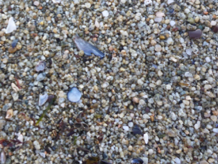
Fig: It’s not just sand! We hope to recover lots of DNA from this sample. There are gulls, seals, mollusks, and lots of algae on the rocky shore nearby.
5:30 a.m. Rise & Shine! Dawn is breaking, so it’s not too tough to get up. Steve’s class is already in the canteen as we pass by. We head out to Horseshoe Cove to take our first sample at 06:32:51 a.m. in the swash zone at Bodega Marine Reserve.

Fig: Burrow openings of animals living in the sediment at Bodega Harbor.
We move up to the nearby bluff to sample the coastal scrub habitat, where the soil is caked and baked, and then repeat about 150 m along the shore. We then find the nearest bay, creek, or estuary—which in this case is Bodega Harbor—where we take another pair of samples, about 12 ml total of sediment, while dozens of folk nearby are pulling all kinds of invertebrates out of their burrows in the mud. So, that is our basic study design, which we’ll repeat 3 more times, over 600 miles apart, and colleagues are replicating throughout California at exactly this time. How cool is that? What an amazing team effort!
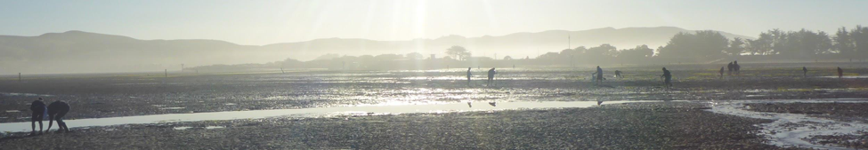
Fig: We’re not the only ones up early collecting stuff from the mudflats of Bodega Harbor. Dozens of folk are digging up invertebrates—worms, crustaceans—that live in the sediment, and birds are nearby.
By 8:00 a.m. we’re heading north on Hwy 1, with Dramamine or a tight focus on the road or the distant views to take the edge off wildly winding road as it weaves around the coastal hills and headlands and drops and climbs steeply through river valleys. By 11 a.m., a little later than hoped, we’re arriving at Van Damme State Park, our second place for sampling eDNA site. SCUBA divers are entering and exiting the water, diving in the kelp. There are some bubbles in the middle of the bay; maybe Waldo is down there? But, it’s too cold for our tired souls, so we won’t be getting a visual. We wrap up and head along the beach to sample our eDNA; maybe we will pick up what the divers are seeing, or the divers’ DNA (and Waldo)?
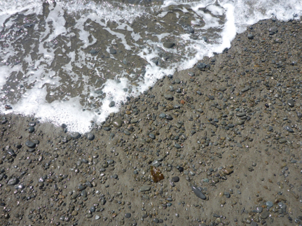
Fig: Van Damme SP swash zone.
With sampling finished for the day, we make a short detour north to Fort Bragg, to the Glass Fire Gallery where we marvel at the blown glass and get a quick tour of the kilns. They’ve some remarkable jellyfish lamps (though Mike can’t identify the species) and glass sea stars—none other than Pisaster, one of the stars of Lauren’s thesis! We watch sand turn to glass (no DNA in that sample!) at over 2000ºC. Then, at a little after noon, we start the long trek south, the longest leg of our trip. We marvel at the coastal redwoods along Hwy 128, blur thousands of rows of grapes in the Williamette valley, and pull off for a few minutes in Booneville to pick up lunch. This is when Lauren realizes she left debit card at the bistro last night, so in 2 hrs we swing through Petaluma for our second encounter with ‘the goat’, retrieve the card, and with spending power back in hand, our next road-stop is the Gilroy outlets, where the boss tries, and fails, to pick up some new sandals for the coming summer. We stretch, and get back in the car for another 3.5 hrs to San Simeon. Nine hours after leaving Fort Bragg, we crash, metaphorically, in the hotel, and with a wireless connection at last, upload some of our valuable data.
Day 3

Fig: Sampling the soil in the bluff took us a little longer, and not just because the view was better.
5:30 a.m. Rise & Shine! Feeling distinctly less shiney than yesterday, and with some bad hotel coffee in hand, our first stop today is the Kenneth S. Norris Rancho Marino Reserve; at 6:43:43 AM, our third set of samples is underway. Rancho Marino is a gem, extending from sea level to 700-foot elevation, harboring one of the three remaining naturally occurring stands of Monterey pine forest in CA. The reserve manager is Don Canestro, who comes to greet us at around 7:00. Don was out yesterday morning, collecting samples from just up the coast at Morro Bay for the CALeDNA project, so we trade notes. We conclude several things: iPhones are great but nothing beats the reliability of pencil, water proof paper, and a clipboard for taking field notes; it’s just an amazing privilege to be able to do this kind of fieldwork; and one of life’s truisms is that sometimes great conversation will have to end when “I’ve got to go milk a goat!” Don heads up the hill, we finish sampling, and grab his samples from Morro Bay on the way out.

Fig: Tide pool
This is where Lauren’s five years of graduate field work experience really comes into play. She guides us faultlessly to the very excellent Linn’s bakery in Cambria, where we stock up for the penultimate leg of the journey, and then charts a route that takes us past the Los Osos Oaks State Natural Reserve where we take 15 minutes to wander through a beautiful copse of live oaks (and not so beautiful swarms of mosquitos).